Press Release
Lytx Identifies the Top 10 Roads for Cell Phone Use in the United States
SAN DIEGO – Feb. 20, 2019 —
Lytx®, the world’s leading provider of video telematics, analytics, productivity and safety solutions for commercial and public sector fleets, today shared data revealing the top 10 stretches of road where Lytx observed the most driver cell phone use, as well as the riskiest roads in the country’s five most populous states.
 Lytx identified areas of Long Beach, Calif.; New York City; and Berkeley, Ill. to be the riskiest of the top five populous states, while Memphis, Tenn. and Los Angeles contain the roads with highest observed cell phone use. Across the U.S., Lytx captured 1,353,837 instances of cell phone use in 2018.
“Commercial drivers face some of the toughest, most hazardous working conditions of any profession. Their routes are constantly being disrupted by construction, weather and traffic, and they share the road with people who aren’t professional drivers,” said Lytx Chairman and CEO Brandon Nixon. “The quantity and quality of our data—we capture 50 billion unique driving data points every day—means we’re uniquely able to understand the complexities commercial drivers face. We glean insights from the data that help our clients zero in on the biggest sources of risk, understand root causes, make better decisions faster, and ultimately, help prevent collisions and make commercial driving safer.”
 Nixon continued, “Our data shows a steady decline in risky driving instances, but these findings highlight the fact that while the transportation community has made great strides in boosting safety on the country’s roadways, fleets and individual drivers need to remain ever vigilant.”
Lytx harnesses the power of video to help clients see what happened in the past, manage their operations more efficiently in the present and improve driver behavior to change the future.
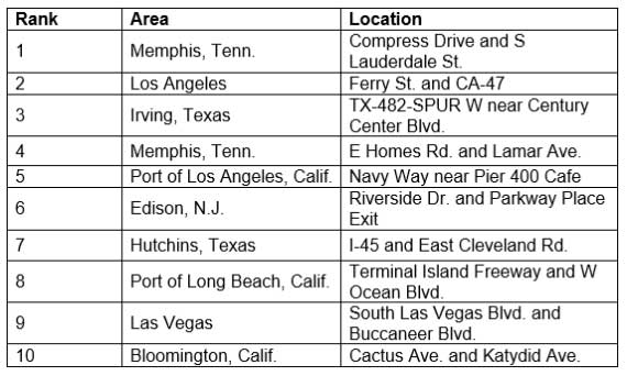
Top 10 Roads in the U.S. for Lytx-Observed Cell Phone Use
The below half square-mile road segments had the highest volume of observed cell phone use behind the wheel in all of 2018, based on Lytx client data from around the country.
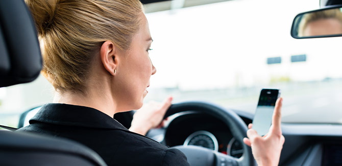
On average, drivers who use handheld cell phones while driving are around 50 percent more likely to get into a collision within 90 days than drivers who do not.
Riskiest Roads
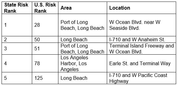
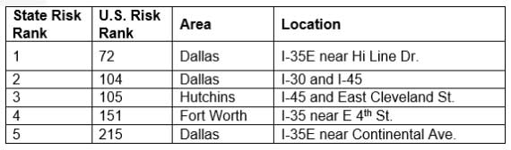
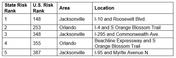
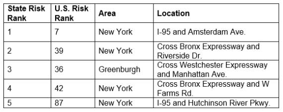
Below are the top five riskiest half square-mile road stretches of 2018 in each of the five most populous U.S. states—California, Illinois, Florida, New York and Texas, based on Lytx’s proprietary risk score system (see “About the Data” section for more information.) The U.S. risk rank column demonstrates how each road segment stacks up against the rest of the country, rather than just in its state.
California
Texas
Florida
New York
Illinois
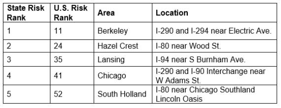
“As expected, the majority of concentrated risk fell in high-density areas, including cities, ports and road stretches with interchanges or on/off ramps, where there are a high volume of merging vehicles and overall activity,” said Kyle Warlick, an intelligence analyst at Lytx who conducted the study. “Based on the U.S. risk ranking, we can see that driving in New York, Illinois and California roads is generally riskier than driving in Texas and Florida, despite those states’ large populations.”
About the Data
Insights are derived from the entire Lytx U.S.-based client database, including public and private fleets in the trucking, waste, transit, government, construction, field services industries, and more, between Jan. 1, 2018 to Dec. 31, 2018. The rankings are according to the Lytx proprietary risk score system. The system calculates risk score by assigning a certain number of risk points to every behavior it tracks based on how correlative that behavior is to causing a collision, such as handheld cell phone use, rolling stops and lane departure.
The riskiest roads highlighted above represent the half square-mile road segments with the highest concentration of risk points in California, Texas, Florida, New York and Illinois throughout calendar year 2018.
The data is anonymized, normalized and generalizable to drivers given the high volume of Lytx event recorders on domestic urban, residential and rural roadways.
Today’s findings are the first in a series of data releases Lytx plans to issue this year, building on the company’s State of the Data presentation delivered at the American Trucking Associations Management Conference and Exhibition (ATA MC&E) in October 2018. The company’s ATA MC&E report included findings on the top five riskiest road segments for North American truck drivers between January and September 2018, among others.
About Lytx
Lytx® is the world’s leading provider of video telematics, analytics, safety and productivity solutions for commercial and public sector fleets. Our unrivaled Driver Safety Program, powered by our best-in-class DriveCam® Event Recorder, is proven to help save lives and reduce risk. We harness the power of video to help clients see what happened in the past, manage their operations more efficiently in the present and improve driver behavior to change the future. Our customizable services and programs span driver safety, risk management solutions, fleet tracking, compliance and fuel management. Using the world’s largest driving database of its kind, along with proprietary machine vision and artificial intelligence technology, we help protect and connect thousands of fleets and more than one million drivers worldwide. For more information, visit www.lytx.com, @lytx on Twitter, LinkedIn, our Facebook page or YouTube channel.